
The world of geospatial intelligence is undergoing a seismic shift, moving from static maps to dynamic, AI-powered insights. But with so much hype around artificial intelligence, which capabilities truly matter for understanding our planet? We dive deep into the core AI functions that are revolutionizing geospatial intelligence. Here are the five capabilities making the biggest …
Autor: lektor
The Impact of Flooding on Communities, Economies, and the Environment

Photo by ål nik on Unsplash
Unlocking Innovation: The Future of AI Edge and Geospatial Intelligence

Photo by Solen Feyissa on Unsplash
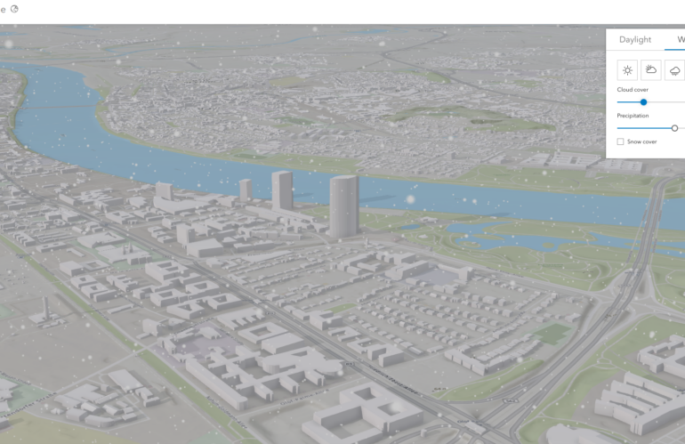
A Vision for the Future of Urban Mobility

In the era of rapid urbanization, understanding and managing urban mobility has become a pressing concern. At the heart of this challenge lies the need for robust, scalable, and precise tools that can simulate and analyze urban traffic patterns. Enter the Geospatial Urban API, a ground-breaking technology that is set to revolutionize our approach to …
Unleashing the Power of Spatial Data
In the rapidly evolving landscape of the digital era, where smart devices, Internet of Things (IoT), and mobile solutions reign supreme, spatial data has emerged as the lifeblood of enterprises. Today, businesses thrive or falter based on their ability to gather, process, and analyze large volumes of spatial data with speed and precision. This paradigm …
Design carbon-effective spatial data science
Carbon-effective means reducing the carbon footprint for an activity or process. Carbon emissions cause global warming and harm to the environment, so we need to focus on reducing them to fight climate change. As geospatial engineers, we have a unique opportunity to make a positive impact on the environment through our work. The design, development, …
Track and reduce your carbon footprint

Spatial data science plays a vital role, revolutionizing various industries and driving progress like never before. However, this technological growth has come at a cost: A rise in carbon dioxide (CO2) emissions. The emissions from cloud data center and their energy consumption contribute to climate change and pose a serious threat to our environment. Therefore, …
Detecting the flooding of Kherson using broadcasted news related to natural disasters

We use broadcasted news to find hotspots for natural disasters. Looking for patterns in the locations mentioned in relation to these disasters is a common geospatial intelligence workflow. This doesn’t just include the place where the event happened, but also other related locations. News about a broken dam near Kherson and mentioning Moscow creates an …
Mapping the broadcasted news related to natural disasters
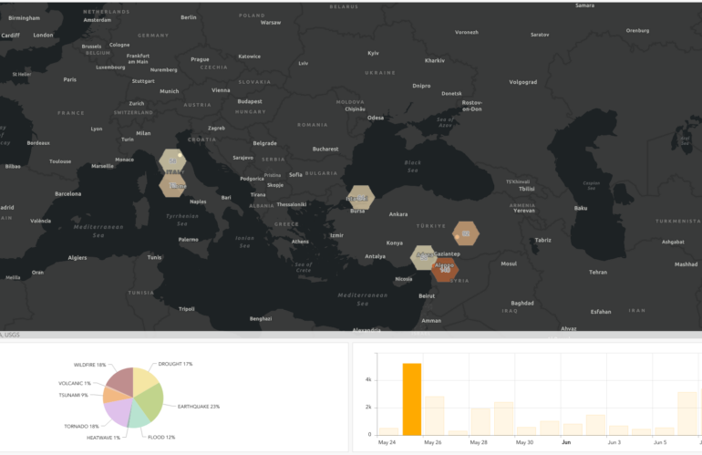
We experienced heavy shifts in temperature and weather patterns. Climate change is related to natural shifts and much more beneficial human activities. The broadcasted news articles related to climate change and the rise of natural disasters describe various cases. A massive knowledge graph saves the extracted semantic entities of the broadcasted news worldwide. Understanding the …
Earth day 2023 visualize the predicted vulnerabilities
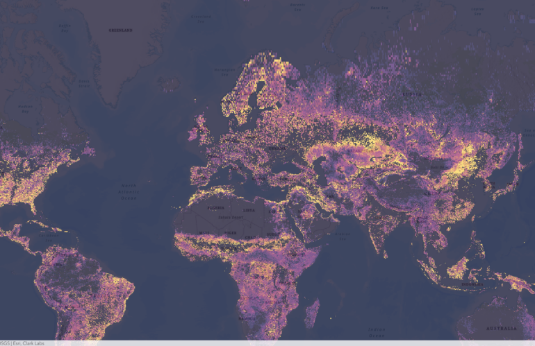
Clark Labs, a research and development company based in Worcester, Massachusetts, is at the forefront of using geospatial intelligence to predict vulnerability change. Through their cutting-edge research, they are harnessing the power of Earth observation data, specifically the maps provided by the European Space Agency (ESA), to create predictive models that can forecast changes in …