Classify locations into well-known land cover categories.
This geospatial intelligence service classifies locations into 44 well-known land cover categories of the Corine database. The database provides a comprehensive classification of land use and land cover across Europe, which can be used for a wide range of applications, from environmental monitoring to urban planning.
For the best performance, a spatial grid aggregates the land cover categories of the Corine database. So that the service classifies the locations against a minimum bounding geospatial region.

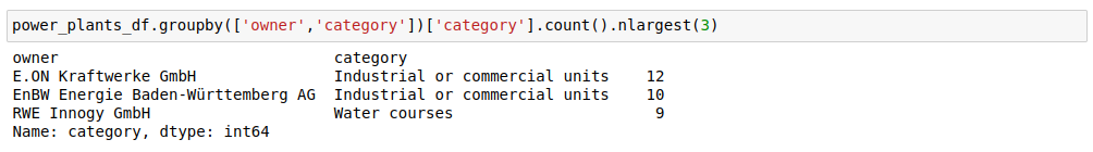
You can easily classify the locations of any entity located in Europe. We did a proof-of-concept using the Open Power System database offering conventional power plants with their technical details.

The service classified every location of the power plants into the well-known land cover categories. So that we aggregated the power plants into the most common categories by ownership.
References:
[1] geolandcover @RapidAPI
Classify locations into well-known land cover categories.
Terms of Use
We designed the geospatial intelligence API services for research and analysis of geospatial knowledge worldwide. The geospatial datasets and any result being generated by these API services are available for unrestricted use for academic, commercial, or governmental use of any kind.
You may redistribute, republish, and mirror the geospatial results in any form.
We created the spatial grid using the full, open and free accessible Corine Land Cover data. This data is produced with funding by the European Union. The detailed licensing conditions can be found here.
© European Union, Copernicus Land Monitoring Service 2018, European Environment Agency (EEA)